
Hialeah ZIP Directory Coverage
Seven standard street-delivery ZIPs have a direct Hialeah relationship, while several special or edge codes need extra care. The table describes broad areas, not legal borders. Miami-Dade’s official ZIP mapping and the city parcel layer should settle an exact address. Postal facilities are useful landmarks, but a station can serve addresses beyond the municipality.
| ZIP | Hialeah area | Postal facility evidence | Boundary note |
|---|---|---|---|
| 33010 | Southeast and central civic core; airport-side industry | Hialeah facility, 325 E 1 Ave | Check airport and industrial edges |
| 33012 | West-central; West 49th and Palm Springs area | Promenade Postal Store, 3690 W 18 Ave | Street delivery plus facilities |
| 33013 | East and northeast Hialeah | Bright, 3200 E 2 Ave | Edge near Opa-locka and industry |
| 33014 | Northwest Hialeah and nearby Miami Lakes area | Palmetto Lakes, 5375 NW 159 St | Extends beyond city limits |
| 33015 | Far northwest postal area | Exact station not located in sources | Many Hialeah labels are outside city |
| 33016 | North and central-west Hialeah | El Mercado, 2440 W 60 St | Check western and northern edges |
| 33018 | West and northwest growth area | Exact station not located in sources | Also serves Hialeah Gardens and county land |
This Hialeah ZIP code directory also separates delivery areas from facility codes. USPS documents identify 33002 for Palm Village at 1050 W 49th Street and 33011 for the Hialeah facility at 325 E 1st Avenue. Those are special or PO-box facility codes, not ordinary neighborhood polygons. Code 33017 appears as a Hialeah postal designation at the Miami Gardens facility, 6193 NW 183rd Street, but it is not a clean Hialeah city neighborhood.
Hialeah Facility ZIPs Explained
A PO-box facility ZIP identifies mail routed through a post office, not every door around it. That is why 33002 and 33011 should not be mapped like 33012 or 33016. A unique ZIP serves one large institution or organization; the research did not establish a unique institutional code for Hialeah, so none should be invented.
The distinction matters in resident research. A box number can identify a mailing route but cannot place a person at a street parcel. Confirm a street address with USPS, then use county property and city GIS fields to see the physical site. When a record contains only a facility ZIP, look for a folio, legal description, case number, license number, or full mailing address before joining it to a person.
Hialeah ZIPs Cross City Lines
ZIPs 33014, 33015, and 33018 illustrate the key local myth: a Hialeah mailing label does not prove that the parcel is inside the City of Hialeah. The same postal areas reach Miami Lakes, Hialeah Gardens, Miami Gardens, and unincorporated Miami-Dade. A parcel inside the city may also carry a postal convention that does not resemble the municipal line.
Boundary check. Use postal geography to route mail. Use the municipal polygon, true situs city, and folio to choose the government office that holds a local record.
This boundary mismatch changes the request desk. Hialeah keeps its own permits, plans, code records, liens, maps, and city police files. A parcel outside Hialeah may belong with another city or a Miami-Dade custodian even if its envelope says Hialeah. County deeds, court files, and property assessment remain Miami-Dade records across those city lines.
Verify Hialeah ZIPs in GIS
The Hialeah Maps Gallery publishes property, zoning, flood, service, historic-aerial, and civic maps. Its zoning layer carries TRUE_SITE_CITY and TRUE_SITE_ZIP_CODE along with separate owner mailing city, state, ZIP, and country fields. Those fields make physical location and owner contact visible as different facts.
Start with a full address in Miami-Dade Property Search. Save the 13-digit folio and legal description. Open the city map, locate the parcel, and compare the true situs city and ZIP to the mailing fields. The folio remains stable across assessor, GIS, and permit systems even when street spelling or postal labels vary.
- Situs
- The parcel’s physical location.
- Mailing address
- Where the owner receives notices; it may be elsewhere.
- Folio
- Miami-Dade’s 13-digit parcel identifier.
- Legal description
- The subdivision, plat, lot, and block description of land.
Find Hialeah Residents by ZIP
Not every official portal offers a simple ZIP-wide list. Use only fields that the custodian provides. Sunbiz has direct ZIP and street-address searches. FDLE supports geographic searches by ZIP. Hialeah GIS exposes true situs ZIP through its layer. County Property Search accepts address, owner, subdivision, or folio, not a public standalone ZIP-wide form. Florida’s personal voter lookup is not a ZIP browser.
- Verify the complete mailing address and ZIP through USPS.
- Check the parcel in county Property Search, then compare true situs and municipal limits in Hialeah GIS.
- Use a direct ZIP search only in an official system that offers one, such as Sunbiz or the FDLE registry.
- For public voter data, send Miami-Dade Elections a scoped Chapter 119 request that names the ZIP, snapshot date, public fields, and electronic format.
- Once the result narrows to an address, use the Hialeah directory by street for parcel-level research.
A ZIP-wide result is still broad. Confirm names with a document number, license, folio, case, or exact street address. Never assume that every filed officer address or parcel owner is a current occupant.
Official Hialeah ZIP Search Fields
Three official sources use ZIP geography in distinct ways. Their controls and results should not be blended. Sunbiz finds organizations tied to filed addresses. FDLE supports a statutory public-safety geography search. GIS establishes the parcel’s true site within Hialeah.
| Official source | ZIP-related input | What results show | Main caution |
|---|---|---|---|
| Sunbiz | ZIP Code or Street Address search mode | Entity name, document number, status, filed contacts | Filed address may not be a residence |
| FDLE registry | Blank-name ZIP geography | Name, legal status, address, source, map | Reported data; no crime or harassment |
| Hialeah GIS | TRUE_SITE_ZIP_CODE layer field | Parcel, folio, true situs, zoning, mailing fields | Map is not certified title |
| USPS ZIP Lookup | Complete street address | Current delivery ZIP | Does not establish city jurisdiction |
The Florida DBPR license search adds location controls for regulated credentials.
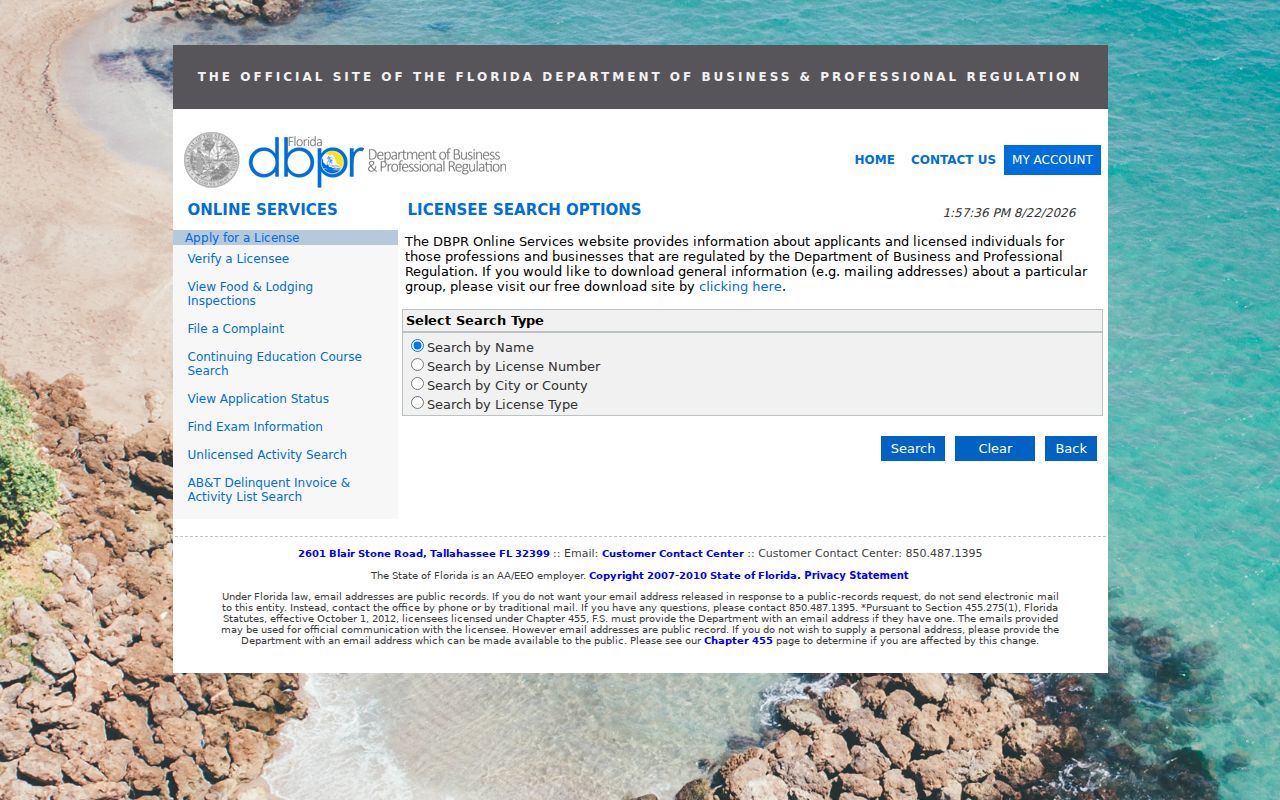
Its city, county, state, category, type, and historic-license controls can refine a ZIP lead without turning a business location into proof of residence.
Use Hialeah ZIP Mode Responsibly
The FDLE offender and predator system allows geographic searching and public output by ZIP. A result may include photograph, name, legal status, address, address-source details, aliases, and a mapped marker. FDLE warns that data come from contributing agencies and registrants and are not independently confirmed.
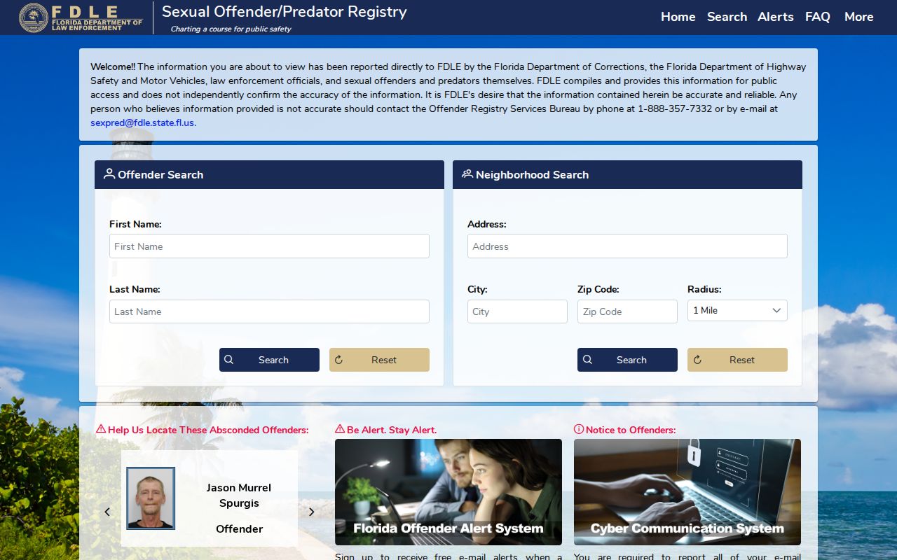
Use the map for its stated public-safety purpose. Contact FDLE about errors. Registry data may not facilitate a crime or harassment, and a ZIP result should never be treated as a general list of Hialeah residents.
Hialeah ZIP Address Precision
Hialeah uses Miami-Dade’s numbered street and avenue grid alongside Palm Avenue, Hialeah Drive, Okeechobee Road, and other named routes. East, West, and NW directionals are not interchangeable. Enter the full directional, road type, and unit when verifying a ZIP. If the result remains unclear, move to the map instead of forcing a text match.
Subdivision and legal-description fields can be more reliable than street spelling. This is especially useful near mixed residential, commercial, airport, and industrial corridors. Hialeah’s GIS includes annexation and unincorporated zoning labels, which help explain why nearby parcels can share postal wording but fall under different local custodians.
Hialeah ZIP Code Definitions
The final Hialeah ZIP code directory check is to name the geographic unit correctly. A five-digit ZIP is a mail-delivery area. It is not a neighborhood, tax district, voting precinct, parcel boundary, or city line. ZIP+4 and carrier routes narrow delivery further but still do not replace municipal GIS.
- ZIP vs ZIP+4
- The five-digit area is broad; four added digits narrow a delivery segment.
- PO-box ZIP
- A code assigned mainly to boxes at a postal facility.
- Unique ZIP
- A code assigned to one very large recipient rather than a neighborhood.
- Carrier route
- A group of addresses served on one postal delivery route.
Keep the four address concepts separate: ZIP routes mail, situs describes the physical parcel, owner mailing shows a contact destination, and the legal description defines land. That distinction prevents most Hialeah boundary and resident-search mistakes.